Coastal Forest as Climate Shields: Carbon Stock Growth and Coastal Protection in Bengkulu City, Indonesia
By Dede Nadia Rahmah (LinkedIn) from the Young Urbanists of Southeast Asia Mentorship Program 2025
5 September 2025
Climate change is becoming an increasingly urgent concern. The impacts of global warming include rising sea levels, intense rainfall events, changes in freshwater supply to the oceans, increased global temperatures and heatwaves, the expansion of tropical ecosystems toward the poles, more intense tropical storms, and more severe droughts, along with a big rise in wildfires (Day et al., 2021). The area on the front line of this issue is coastal regions, including coastal cities. These cities will serve as a benchmark for understanding what could happen if climate change is not effectively managed. This is due to their proximity to several key climate change variables, such as sea-level rise and increasing frequency and intensity of heatwave. Such impacts will threaten the sustainability and resilience of coastal cities, especially those located in the tropical-subtropical belt.
Indonesia, as an archipelagic country, has many coastal cities. The main focus of this discussion is Bengkulu City, which is located in a tropical area highly vulnerable to the climate change effects described above. In 2023, Bengkulu experienced significant wildfires, with 59 cases of forest and land fires recorded during the dry season. Fire-prone areas included golf courses, the Panjang Beach area, the Nature Tourism Park in Black River, residential land in Betungan, and the Sebakul Water area (Febrianto, 2023). According to Katadata (2025), Bengkulu recorded the highest number of hotspots in Indonesia, with 43 hotspots, making it more vulnerable to the impacts of climate change.
Coastal cities often experience urban sprawl along the coastline. While this spatial expansion can improve transportation systems, raise living standards, and promote tourism, it can also harm coastal biodiversity, increase waste production and pollution, and lead to the overexploitation of natural resources (BPIW PU Indonesia, 2017). These factors contribute to higher greenhouse gas emissions, which in turn worsen the effects of climate change. One potential solution is the restoration of mangroves or other coastal forests. In total, mangrove forests span 247.61 hectares, with 118.14 hectares specifically designated as part of TWA Pantai Panjang–Baai Island (Sumarmi & Bachri, 2025). This paper examines the potential of mangrove and coastal vegetation as a carbon storage strategy to mitigate climate change in coastal cities.

Coastal forests in Bengkulu City was able to absorb up to 337,981 tons CO2e in 2014.
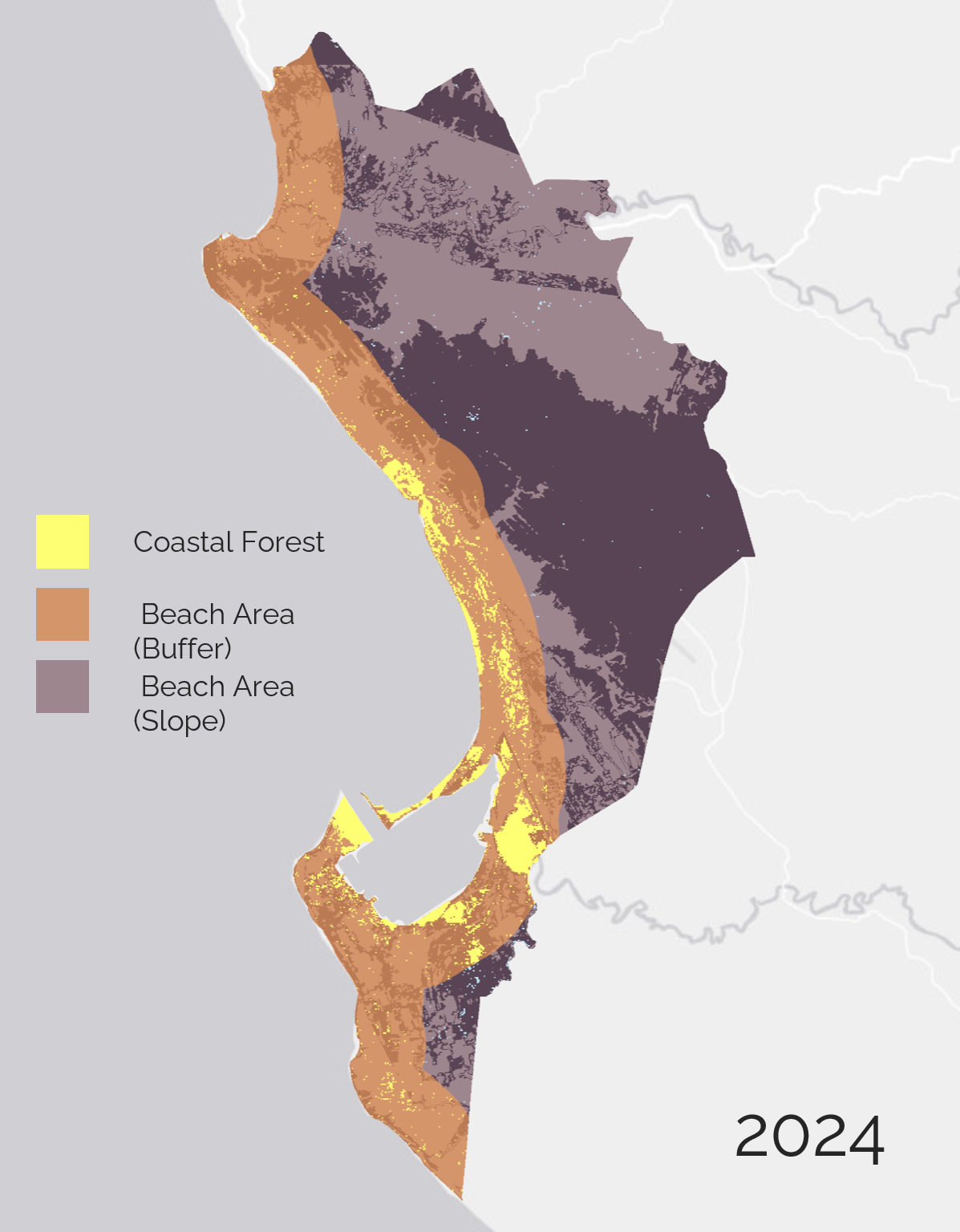
Coastal forests in Bengkulu City increased to absorb up to 509,524 tons CO2e in 2024.
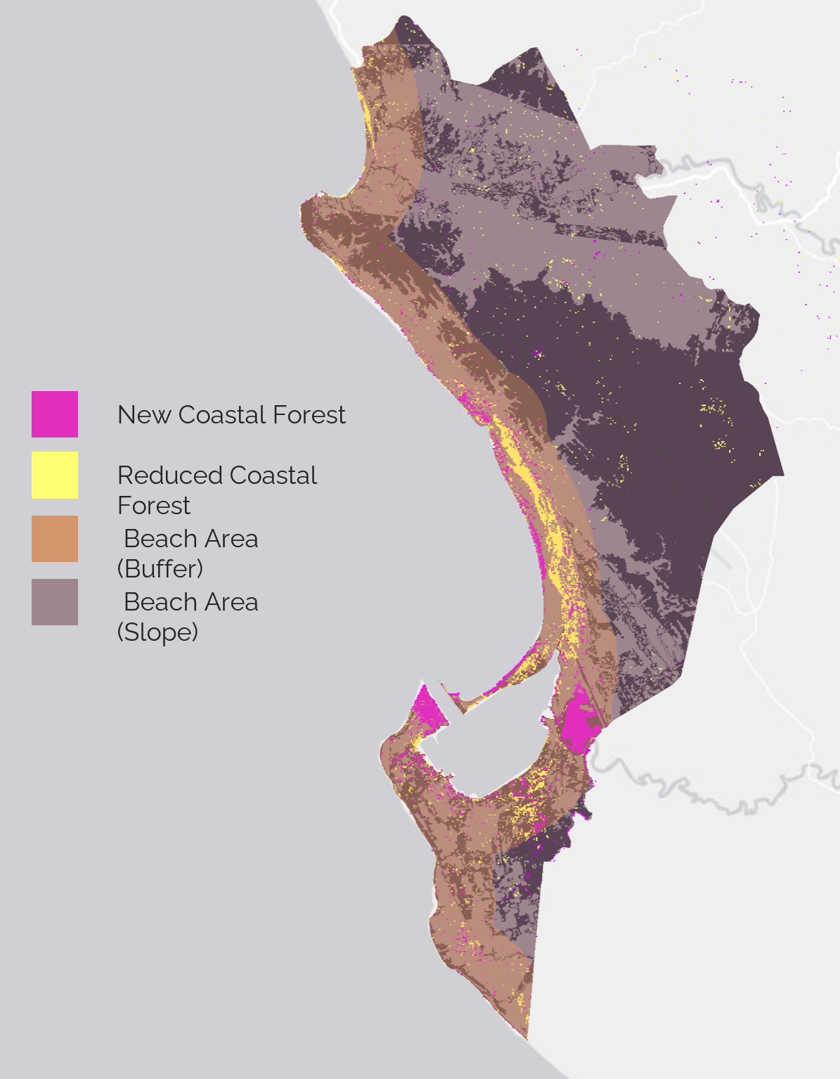
The increase between 2014-2024 was +171,543 tons CO2e in carbon absorption.
Over the past decade, Bengkulu City has seen a significant increase in mangrove or coastal vegetation coverage. Through a labor-intensive program under the National Economic Recovery initiative, as part of efforts to support climate action and sustainable development, it has directly boosted its carbon storage capacity. In 2014, the total carbon stock of mangroves in the city was estimated at 337,981 tons CO2e. By 2024, this figure had grown to 509,524 tons CO2e, a net increase of 171,543 tons CO2e over ten years. This notable growth highlights the crucial role of mangrove ecosystems as natural carbon sinks.
The data shows that expanding mangrove areas not only aids in carbon sequestration but also supports broader climate change mitigation efforts at the local level. As highlighted by Arifanti et al. (2022), mangroves are carbon-rich ecosystems that capture and preserve significant quantities of carbon, helping to counterbalance anthropogenic greenhouse gas emissions. By absorbing atmospheric CO₂, mangroves help lower greenhouse gas concentrations and reduce overall carbon footprints. Furthermore, increasing mangrove biomass enhances the ecological resilience of coastlines, as these ecosystems provide vital services such as sediment regulation and protection against erosion, storm surges, and sea-level rise. This underscores the importance of mangrove expansion in both climate mitigation and adaptation strategies.
These findings strengthen the case that mangrove restoration and conservation should be a priority in Bengkulu’s coastal management policies. Over a relatively short period of ten years, the rise in carbon stock demonstrates that nature-based solutions can deliver measurable climate benefits while also preserving the health and productivity of coastal ecosystems.
Methodology
Study Area and Data: The study was conducted in Bengkulu City, Indonesia, focusing on coastal vegetation distribution and carbon stock estimation. Landsat 8 OLI/TIRS Collection 2 Level 2 surface reflectance imagery was acquired for May–June 2014 and May–June 2024 to minimize cloud contamination and seasonal variability.
Pre-processing: Landsat Image was analyzed using Google Earth Engine. The first step was cloud masking, where pixels affected by clouds and cloud shadows were removed using the QA_PIXEL band. Cloud shadow was identified using bit 3, and cloud using bit 4, with masked pixels excluded from further analysis.
Next, the surface reflectance values were converted using the USGS scaling factor to ensure physically meaningful values for spectral index computation:
Reflectance = (DN x 0.0000275)-0.2Spectral indices: To improve class separability, six spectral indices were computed. These indices were appended as additional bands to the imagery (Sowjanya & Prasad, 2024).
Normalized Difference Vegetation Index (NDVI), which measures vegetation greenness:
NDVI = (NIR - Red) / (NIR + Red)Normalized Difference Moisture Index (NDMI), which indicates vegetation water content:
NDMI = (SWIR2 - Green) / (SWIR2 + Green)Modified Normalized Difference Water Index (MNDWI), which highlights water bodies:
MNDWI = (Green - SWIR1) / (Green + SWIR1)Simple Ratio (SR), ratio of NIR to Red reflectance:
SR = NIR/REDBand Ratio R54, ratio of SWIR1 to NIR:
R54 = SWIR1 / NIRGreen Chlorophyll Vegetation Index (GCVI), which estimates chlorophyll content:
GCVI = (NIR / Green)-1
Supervised Classification: A supervised classification was conducted using two land cover classes: coastal vegetation (Class = 1) and non-vegetation (Class = 0). Training samples were manually digitized from high-resolution basemaps. The Classification and Regression Tree (CART) algorithm was applied, using both reflectance bands and spectral indices as predictors.
Carbon Stock Estimation: Above-ground carbon stock was calculated only for pixels classified as vegetation. A mean carbon density of 226 Mg C ha⁻¹ (midpoint of the range 96–356 Mg C ha⁻¹ based on Basyuni et al., 2024) was applied. Each Landsat pixel covers 0.09 ha, and carbon per pixel was computed as:
Carbon (tons) = 226 x 0.09The total carbon stock was derived by summing per-pixel values using the reduceRegion function in GEE.
Reference
Arifanti, V. B., Kauffman, J. B., Subarno, Ilman, M., Tosiani, A., & Novita, N. (2022). Contributions of mangrove conservation and restoration to climate change mitigation in Indonesia. Global Change Biology, 28(15), 4523-4538. https://doi.org/10.1111/gcb.16216
Badan Pengembangan Infrastruktur Wilayah (BPIW) Ministry of Public Works of the Republic of Indonesia. 2017. Kamus Digital Istilah Pengembangan. https://bpiw.pu.go.id/bankdata/dictionary/words?q=Kota+pesisir+%28coastal+cities%29&id=1071
Basyuni, M., Aznawi, A. A., Rafli, M., Tinumbunan, J. M. T., Gultom, E. T., Lubis, R. D. A., ... & Baba, S. (2024). Harnessing biomass and blue carbon potential: Estimating carbon stocks in the vital wetlands of Eastern Sumatra, Indonesia. Land, 13(11), 1960. https://doi.org/10.3390/land13111960
Bengkulu Government. 2019. Tanam Mangrove, Upaya Bengkulu Selamatkan Bumi Dari Perubahan Iklim. https://bengkuluprov.go.id/tanam-mangrove-upaya-bengkulu-selamatkan-bumi-dari-perubahan-iklim/
Day, J. W., Gunn, J. D., & Burger, J. R. (2021). Diminishing opportunities for sustainability of coastal cities in the anthropocene: A review. Frontiers in Environmental Science, 9, 663275. https://doi.org/10.3389/fenvs.2021.663275
Febrianto, N. 2023. Bengkulu Experienced 59 Forest and Land Fire Incidents 54 Firefighters Alerted at Vulnerable Points. VOI. URL: https://voi.id/fr/berita/310320
Sowjanya, D. S., & Prasad, P. R. C. (2024). Comparative evaluation of machine learning algorithms for Coringa Mangroves mapping with satellite imagery and spectral indices. Journal of Earth System Science, 134(1), 1. https://doi.org/10.1007/s12040-024-02463-4
Sumarmi, S., & Bachri, S. 2025. Analysis of NDVI, NDWI, and SAVI Transformations for Identification of Mangrove Density in Bengkulu. GeoEco, 11(2), 501-518. https://doi.org/10.20961/ge.v11i2.86711